Kok Kroes (Kandaek)
| Native Name | គោកគ្រឹះ |
|---|---|
| BA# | C1709074 |
| CISARK# | 2314 |
| IK# | 589.09 |
| Size | Small |
| Condition | Tuol |
| Type | Temple |
| Location | |
| Village | Trang |
| Commune | Kandaek |
| District | Prasat Bakong |
| Province | Siem Reap |
| Country | Cambodia |
| Coordinates | 13.36297, 103.94147 |
| History | |
| Material | Brick |
| Year/s Restored | Destroyed |


![]()
![]() Kok Kroes (គោកគ្រឹះ - Pronounced: Kouk Kruhs!)
Kok Kroes (គោកគ្រឹះ - Pronounced: Kouk Kruhs!)
The remains of a former brick temple site, where early reports showed the brick foundation still present. However unfortunately today there is nothing remaining as the area has been marked for re-development, as evident by the new road that loops around it. The centre of the mound can be seen to be no longer as raised, with numerous areas that look like mini ponds now, that would indicate two likely things, 1. tomb raiders searching for lost treasures or 2. the soil from the mound is being used to re-purpose the development area.
Looking back at historic satellite imagery, one can easily pin point the bushy raised mound surrounded by a seasonally filled moat with an east entrance causeway that leads onto a small rectangular 70m x 35m man-made reservoir 50m away.
Map Location
Image Gallery
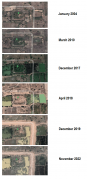
Historic satellite imagery

If you would like to upload additional images to the gallery, please refer to the Upload Instructions guide
Historic Archive
A collection of historic photographs, artist sketches, maps etc. (Please ensure that anything you do upload is free of copyright and/or you have permission from the original photographer/artist/author to share)
Nearby Sites
- Baray Prasat Kok Chak (Prasat Bakong)
- Baray Prasat Prei Preah Put
- C1709236
- C1709237
- C1709238
- C1709241
- C1710019
- C1710020
- C1710337
- C1710356
- C1710447
- Kok Arak (Kandaek)
- Kok Kroes (Kandaek)
- Kok Kroes (Prei Koy)
- Kok Kroes (Trang)
- Kok Roka (Trang)
- Kok Ta But
- Kok Ta Kaong
- Kok Ta Sau
- Kok Thveng
- Kok Yeay Lai
- Kroes Kok Kanhchoan
- O Spean Daek
- Prasat Kandaol Dom Khang Cheung
- Prasat Kandaol Dom Khang Tboung
- Prasat Kok Beng (Siem Reap)
- Prasat Kok Chak (Prasat Bakong)
- Prasat Kok Kroes (Spean Ka-aek)
- Prasat Kok Ta Lek
- Prasat Kroes Tnaot Te
- Prasat O Ka-aek
- Prasat Ov Laok
- Prasat Trapeang Boeng
- Trapeang Boeng (Prasat Bakong)
- Trapeang Daun Sau
- Trapeang Kaong
- Trapeang Ponlei
- Trapeang Ta Trao
- Trapeang Ta Trao Thom
- Trapeang Thlok Andenh
- Tuol Bakong
- Tuol Ponlei I
- Tuol Ponlei II
- Tuol Prasat Prei Preah Put
- Tuol Prei Roka
- Tuol Ta Te
- Tuol Ta Trav
- Wat Kok Chan
External Links
Links to additional resources such as articles, websites, videos etc.
References