Muang Sema: Difference between revisions
No edit summary |
mNo edit summary |
||
| (8 intermediate revisions by 2 users not shown) | |||
| Line 7: | Line 7: | ||
| ik_no = 448 | | ik_no = 448 | ||
| k_inscr_no = K.400, K.1141 | | k_inscr_no = K.400, K.1141 | ||
| inscr_location = [[]], [[Kanchanaphisek National Museum]] | | inscr_location = [[Phimai National Museum]], [[Kanchanaphisek National Museum]] | ||
| size_of_site = | | size_of_site = | ||
| condition_of_site = | | condition_of_site = | ||
| Line 30: | Line 30: | ||
| verification = | | verification = | ||
}} | }} | ||
[[File: | [[File:T30170 Muang Sema.jpg|link=|left|250px]] | ||
<vote type=1 /> | <vote type=1 /> | ||
| Line 39: | Line 39: | ||
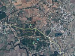
A sprawling ancient city site housing various temple ruins as well as some well-preserved moats and embankments which reveals several distinct construction/occupation periods. A moated, irregular-shaped, core area on the south side of the ancient city, measuring some 600m x 1100 at its widest points, was likely to have been the earliest occupation site and today features several Dvaravati-period brick vestiges. (1) | A sprawling ancient city site housing various temple ruins as well as some well-preserved moats and embankments which reveals several distinct construction/occupation periods. A moated, irregular-shaped, core area on the south side of the ancient city, measuring some 600m x 1100 at its widest points, was likely to have been the earliest occupation site and today features several Dvaravati-period brick vestiges. (1) | ||
A presumably, subsequent expansion of the site - also still featuring a largely intact moat and embankments - extended it by over 1 km to the north. In the centre of this northern extension a more geometric, again moated, area is distinguishable on satellite images and perhaps corresponds to a later construction period. [[Muang Sema Monument 7]], sometimes known as | A presumably, subsequent expansion of the site - also still featuring a largely intact moat and embankments - extended it by over 1 km to the north. In the centre of this northern extension a more geometric, again moated, area is distinguishable on satellite images and perhaps corresponds to a later construction period. This section of the ancient city seems to correspond to the CISARK entry 1883 and is listed separately as [[Kaen Thau]]. [[Muang Sema Monument 7]], sometimes known as Bo Ika, is located immediately east of the rectangular moat otherwise no major vestiges have been identified in this northern section. Ceremonial sites and early-period important buildings were located in the southern section with possibly the majority of the population to the north. The more rectangular central area with a moat and double embankment indicates a defensive purpose and speculatively may have been added at a later date to house the city garrison or even some kind of palace complex. | ||
The site was clearly one of major importance over a lengthy time frame and indeed there was a branch of the famous 'Angkor Road' from Angkor Wat to Phimai ([[ | The site was clearly one of major importance over a lengthy time frame and indeed there was a branch of the famous 'Angkor Road' from Angkor Wat to Phimai ([[Vimayapura]]) leading directly to the city. The site's importance appears to have faded in the post-13th century era with the nearby, present-day provincial capital, [[Muang Nakhon Ratchasima]] taking up the baton. | ||
(1) Note that in this case, we are employing Dvaravati as a cultural rather than ethnic description and while early Muang Sema was clearly influenced by [[Muang Boran Si Thep]] as well as the Mon cities of the central plains, it is likely that such southern reaches of the Khorat Plateau had been inhabited by ethnic Khmers long before the extension of Angkorean control over the region from the 9th century onwards. | There are numerous temple ruins and vestiges scattered in and around Muang Sema and while the overall site clearly retained its importance during the period of Angkorean administration, we are only listing the individual temple sites which display direct Khmer architectural features or artefacts. | ||
Two significant inscriptions were found at Muang Sema; the Bo Ika stele, (K.400), unearthed at [[Muang Sema Monument 7]] and K.1141 whose provenance is merely listed as Muankg Sema. The latter is dated to 971 and the early years of the reign of Jayavarman V. See details on the external link below while, for the Bo Ika inscription, see Monument 7. | |||
(1) ''Note that in this case, we are employing Dvaravati as a cultural rather than ethnic description and while early Muang Sema was clearly influenced by [[Muang Boran Si Thep]] as well as the Mon cities of the central plains, it is likely that such southern reaches of the Khorat Plateau had been inhabited by ethnic Khmers long before the extension of Angkorean control over the region from the 9th century onwards.'' | |||
== Map Location == | == Map Location == | ||
{{ | {{#cargo_compound_query:tables=Sites | ||
| | ;where=part_of HOLDS "[[Muang Sema]]" AND type_of_site HOLDS "[[:category:Ancient Reservoir|Ancient Reservoir]]" | ||
;fields=_pageName,native_name_lang,alternate_name,ba_no,condition_of_site,size_of_site,type_of_site,coordinates | |||
;icon=M-reservoir.png | |||
|tables=Sites | |||
;where=part_of HOLDS "[[Muang Sema]]" AND size_of_site="Medium" AND condition_of_site="Ruin" AND type_of_site HOLDS "Temple" | |||
;fields=_pageName,native_name_lang,alternate_name,ba_no,condition_of_site,size_of_site,type_of_site,coordinates | |||
;icon=M-m-ruin.png | |||
|tables=Sites | |||
;where=part_of HOLDS "[[Muang Sema]]" AND size_of_site="Small" AND condition_of_site="Ruin" AND type_of_site HOLDS "Temple" | |||
;fields=_pageName,native_name_lang,alternate_name,ba_no,condition_of_site,size_of_site,type_of_site,coordinates | |||
;icon=M-s-ruin.png | |||
|tables=Sites | |||
;where=part_of HOLDS "[[Muang Sema]]" AND type_of_site HOLDS "[[:category:Ancient Village|Ancient Village]]" | |||
;fields=_pageName,native_name_lang,alternate_name,ba_no,condition_of_site,size_of_site,type_of_site,coordinates | |||
;icon=M-village.png | |||
|limit=10000 | |||
|offset=0 | |||
|format=googlemaps | |||
}} | }} | ||
== Image Gallery == | == Image Gallery == | ||
<gallery mode="packed-hover"> | <gallery mode="packed-hover"> | ||
File: | File:T30170 Muang Sema.jpg| | ||
File:T30171 Muang Sema Monument 1.jpg| | |||
File:T30171 Muang Sema Monument 4.jpg| | |||
</gallery> | </gallery> | ||
| Line 94: | Line 123: | ||
[[Category:Nakhon Ratchasima Province|S]] | [[Category:Nakhon Ratchasima Province|S]] | ||
[[Category:Thailand|S]] | [[Category:Thailand|S]] | ||
Latest revision as of 05:57, 24 June 2024
| Native Name | เมืองเสมา, មឿងសីមា |
|---|---|
| Alternative name | Sri Canasa, Canasapura, Mueang Ratchasima Kao, |
| BA# | T30170 |
| CISARK# | 6024, 985 |
| IK# | 448 |
| K Inscription | K.400, K.1141 |
| Inscr. Location | Phimai National Museum, Kanchanaphisek National Museum |
| Type | Ancient City |
| Location | |
| Part of | Muang Sema |
| Commune | Sema |
| District | Sung Noen |
| Province | Nakhon Ratchasima |
| Country | Thailand |
| Coordinates | 14.92243, 101.79774 |
| History | |
| Founded | 7th - 12th Century |
| Builder | Various |
| Religion | Buddhism, Hinduism |
| Year/s Restored | Various |


![]() Muang Sema (เมืองเสมา - Pronounced: Moo-ang Say-ma)
Muang Sema (เมืองเสมา - Pronounced: Moo-ang Say-ma)
A sprawling ancient city site housing various temple ruins as well as some well-preserved moats and embankments which reveals several distinct construction/occupation periods. A moated, irregular-shaped, core area on the south side of the ancient city, measuring some 600m x 1100 at its widest points, was likely to have been the earliest occupation site and today features several Dvaravati-period brick vestiges. (1)
A presumably, subsequent expansion of the site - also still featuring a largely intact moat and embankments - extended it by over 1 km to the north. In the centre of this northern extension a more geometric, again moated, area is distinguishable on satellite images and perhaps corresponds to a later construction period. This section of the ancient city seems to correspond to the CISARK entry 1883 and is listed separately as Kaen Thau. Muang Sema Monument 7, sometimes known as Bo Ika, is located immediately east of the rectangular moat otherwise no major vestiges have been identified in this northern section. Ceremonial sites and early-period important buildings were located in the southern section with possibly the majority of the population to the north. The more rectangular central area with a moat and double embankment indicates a defensive purpose and speculatively may have been added at a later date to house the city garrison or even some kind of palace complex.
The site was clearly one of major importance over a lengthy time frame and indeed there was a branch of the famous 'Angkor Road' from Angkor Wat to Phimai (Vimayapura) leading directly to the city. The site's importance appears to have faded in the post-13th century era with the nearby, present-day provincial capital, Muang Nakhon Ratchasima taking up the baton.
There are numerous temple ruins and vestiges scattered in and around Muang Sema and while the overall site clearly retained its importance during the period of Angkorean administration, we are only listing the individual temple sites which display direct Khmer architectural features or artefacts.
Two significant inscriptions were found at Muang Sema; the Bo Ika stele, (K.400), unearthed at Muang Sema Monument 7 and K.1141 whose provenance is merely listed as Muankg Sema. The latter is dated to 971 and the early years of the reign of Jayavarman V. See details on the external link below while, for the Bo Ika inscription, see Monument 7.
(1) Note that in this case, we are employing Dvaravati as a cultural rather than ethnic description and while early Muang Sema was clearly influenced by Muang Boran Si Thep as well as the Mon cities of the central plains, it is likely that such southern reaches of the Khorat Plateau had been inhabited by ethnic Khmers long before the extension of Angkorean control over the region from the 9th century onwards.
Map Location
Image Gallery


If you would like to upload additional images to the gallery, please refer to the Upload Instructions guide
Historic Archive
A collection of historic photographs, artist sketches, maps etc. (Please ensure that anything you do upload is free of copyright and/or you have permission from the original photographer/artist/author to share)
Nearby Sites
- Ban Kut Hin (Sung Noen)
- Ban Som Kob Ngam
- Baray Prasat Muang Kao
- Charuk Sung Noen
- Kaen Thau
- Khok Ka Phi
- Muang Sema
- Muang Sema Monument 1
- Muang Sema Monument 7
- Prasat Ban Bu Yai
- Prasat Hin Muang Khaek
- Prasat Hin Sra Phleng
- Prasat Hua Sra
- Prasat Muang Kao
- Prasat Non Ku
- Sra Phleng (Sung Noen)
- T30164
- T30165
- T30179
- T30182
- Thale Nai
- Wat Ban Kaen Thao
- Wat Non Kum
- Wat Santi Kawat
- Wat Thammachak Semaram
- Wat Thanon Nadi Sirattana Wararam
External Links
Links to additional resources such as articles, websites, videos etc.
Details and photographs of the inscription from the SAC website
The search for Sri Cnasa by the Southeast Asian Kingdoms website
References