C1701171: Difference between revisions
(Created page with "{{Infobox site | name = C1701171 | native_name_lang = មិនស្គាល់ | alternate_name = | ba_no = C1701171 | cisark_no = | ik_no...") |
mNo edit summary |
||
| (One intermediate revision by the same user not shown) | |||
| Line 13: | Line 13: | ||
| part_of = | | part_of = | ||
| village = | | village = | ||
| commune = Daun | | commune = Daun Peng | ||
| district = [[:category:Angkor Chum|Angkor Chum]] | | district = [[:category:Angkor Chum|Angkor Chum]] | ||
| province = [[:category:Siem Reap Province|Siem Reap]] | | province = [[:category:Siem Reap Province|Siem Reap]] | ||
| Line 28: | Line 28: | ||
| unesco_proposed = | | unesco_proposed = | ||
| unesco_tentative = | | unesco_tentative = | ||
| verification = | | verification = Unconfirmed | ||
}} | }} | ||
[[File: | [[File:C1701171.jpg|link=|left|250px]] | ||
<vote type=1 /> | <vote type=1 /> | ||
[[File:Unknown.jpg|frameless|link=:category: | [[File:Unknown.jpg|frameless|link=:category:Unconfirmed|Site Size & Condition: Unconfirmed]] | ||
[[File:Reservoir.jpg|frameless|link=:category:Ancient Reservoir|Site Size & Condition: Ancient Reservoir]] | [[File:Reservoir.jpg|frameless|link=:category:Ancient Reservoir|Site Size & Condition: Ancient Reservoir]] | ||
C1701171 (មិនស្គាល់ - Pronounced: Unknown) it is not known what is in situ. <br> | C1701171 (មិនស្គាល់ - Pronounced: Unknown) it is not known what is in situ. <br> | ||
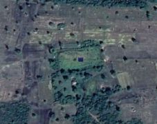
According to satellite imagery, there appears to be a rectangular 100m x 50m man-made reservoir located in the middle of the rice paddy fields. | According to satellite imagery, there appears to be a rectangular 100m x 50m man-made reservoir located in the middle of the rice paddy fields and oriented about 85 degrees. | ||
{{Unknown Sites}} | {{Unknown Sites}} | ||
| Line 50: | Line 50: | ||
== Image Gallery == | == Image Gallery == | ||
<gallery mode="packed-hover"> | <gallery mode="packed-hover"> | ||
File: | File:C1701171.jpg| | ||
</gallery> | </gallery> | ||
{{Image Upload}} | {{Image Upload}} | ||
| Line 81: | Line 82: | ||
[[Category: | [[Category:Unconfirmed|U]] | ||
[[Category:Ancient Reservoir|U]] | [[Category:Ancient Reservoir|U]] | ||
[[Category:Angkor Chum|U]] | [[Category:Angkor Chum|U]] | ||
[[Category:Siem Reap Province|U]] | [[Category:Siem Reap Province|U]] | ||
[[Category:Cambodia|U]] | [[Category:Cambodia|U]] | ||
[[Category:No CISARK|U]] | [[Category:No CISARK|U]] | ||
[[Category:Require Verification Siem Reap|U]] | [[Category:Require Verification Siem Reap|U]] | ||
Latest revision as of 03:54, 4 May 2023
| Native Name | មិនស្គាល់ |
|---|---|
| BA# | C1701171 |
| Size | Small |
| Condition | Intact |
| Type | Ancient Reservoir |
| Location | |
| Commune | Daun Peng |
| District | Angkor Chum |
| Province | Siem Reap |
| Country | Cambodia |
| Coordinates | 13.71851, 103.72041 |
| History | |
| Verification | Unconfirmed |

![]()
![]() C1701171 (មិនស្គាល់ - Pronounced: Unknown) it is not known what is in situ.
C1701171 (មិនស្គាល់ - Pronounced: Unknown) it is not known what is in situ.
According to satellite imagery, there appears to be a rectangular 100m x 50m man-made reservoir located in the middle of the rice paddy fields and oriented about 85 degrees.
If you happen to be in the area and visit this site, we would love to find out more about the site such as the name of the site, the size and condition of the site, what is still in situ and a few photos of the site.
We highly recommend that you consult a local guide or villager to escort you to the site, as there is a possibility of mines or UXO's when visiting remote and secluded sites. If you do decide to venture out on your own, please follow the beaten path and becareful!
Beyond Angkor does not guarantee that you will find any remains at this site. The site has been listed based a probability of a site existing at this particular location. We are not equip with 1.5 million dollar LIDAR equipment like the professional archaeologists, to scan the landscape for ancient formations, instead we have simply used the naked eye on satellite imagery to determine these 'probable' historic sites. We are pleased to say that a large number of sites we seeked remotely from the comforts of our own home, have been confirmed to be in fact 'tuols'. As sites are confirmed by explorers and reported, we have then appropriately relisted the sites with the local name and details of what have been found in situ. These sites can be found in the category No CISARK.
Beyond Angkor and the team at Beyond Angkor are not liable for any damages or injuries sustained when seeking out any historical sites listed, especially of these unknown sites. Please ensure you have the relevant travel insurance for your journey and let someone know where you are headed each day.
Map Location
Image Gallery
If you would like to upload additional images to the gallery, please refer to the Upload Instructions guide
Historic Archive
A collection of historic photographs, artist sketches, maps etc. (Please ensure that anything you do upload is free of copyright and/or you have permission from the original photographer/artist/author to share)
Nearby Sites
- Baray Kok Ream
- Baray Kok Ta Khlang
- Baray Prasat Trav
- C1701026
- C1701051
- C1701053
- C1701107
- C1701115
- C1701128
- C1701129
- C1701134
- C1701162
- C1701163
- C1701164
- C1701165
- C1701166
- C1701168
- C1701169
- C1701170
- C1701171
- C1701172
- C1701173
- C1701174
- C1701201
- C1701288
- C1701292
- C1701293
- C1701294
- C1701295
- C1701296
- Kok Ka Rolom
- Kok Ream
- Kok Sakor
- Kok Ta Eth
- Kok Ta Khlang
- Kok Ta Ku
- Kok Yeang (Angkor Chum)
- Prasat Trav
- Spean Chambok
External Links
Links to additional resources such as articles, websites, videos etc.
References

