Spean Thma (Nokor Thom)
| Native Name | ស្ពានថ្ម |
|---|---|
| Alternative name | Spean Thmor |
| BA# | C1710124 |
| CISARK# | 392 |
| IK# | 491 |
| Size | Medium |
| Condition | Ruin |
| Type | Ancient Bridge |
| Location | |
| Part of | Angkor |
| Commune | Nokor Thom |
| District | Krong Siem Reap |
| Province | Siem Reap |
| Country | Cambodia |
| Coordinates | 13.44610, 103.87953 |
| History | |
| Material | Laterite, Sandstone |
| UNESCO Inscription | 1992 |
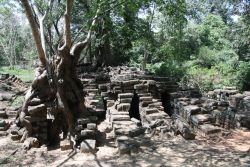


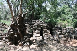
![]() Spean Thma (ស្ពានថ្ម - Pronounced: Spien T'mor) This ancient bridge isn't your standard ancient bridge that can be found along many of the Royal Highways. This particular bridge was constructed from sandstone blocks taken from nearby temples and shrines. When walking around the site one can see fragments of carved sandstone throughout a large portion of the construction. It is likely that the ancient Khmers haphazardly built this bridge as the river changed course over time and reused any stone blocks they could gather. Overtime the river changed course again and to the north one will see that the water level has now dropped extensively compared to the height of this bridge.
Spean Thma (ស្ពានថ្ម - Pronounced: Spien T'mor) This ancient bridge isn't your standard ancient bridge that can be found along many of the Royal Highways. This particular bridge was constructed from sandstone blocks taken from nearby temples and shrines. When walking around the site one can see fragments of carved sandstone throughout a large portion of the construction. It is likely that the ancient Khmers haphazardly built this bridge as the river changed course over time and reused any stone blocks they could gather. Overtime the river changed course again and to the north one will see that the water level has now dropped extensively compared to the height of this bridge.
Map Location
Image Gallery
Ancient sandstone bridge in ruins

Ancient sandstone bridge in ruins


If you would like to upload additional images to the gallery, please refer to the Upload Instructions guide
Historic Archive
A collection of historic photographs, artist sketches, maps etc. (Please ensure that anything you do upload is free of copyright and/or you have permission from the original photographer/artist/author to share)
Nearby Sites
- Angkor Thom Khloung Thvear Chey
- Angkor Thom Khloung Thvear Khmaoch
- Angkor Thom Laterite Edicule N
- Angkor Thom Laterite Steps
- Angkor Thom Spean Chey
- Angkor Thom Spean Khmaoch
- Kampong Phae Thnal Baray
- Prasat Chau Say Tevoda
- Prasat Leak Neang (Nokor Thom)
- Prasat Ta Keo (Siem Reap)
- Prasat Ta Mau (Nokor Thom)
- Prasat Ta Nei
- Prasat Thommanon
- Selacharuk Thnal Baray Piek Niradei
- Spean Thma (Nokor Thom)
- Thvear Sonteas Toek Baray
- Toe Toek Thnal Baray
- Tuol (Angkor) I
External Links
Links to additional resources such as articles, websites, videos etc.
References