Tuol Ta Meung
Jump to navigation
Jump to search

| Native Name | ទួលតាមឿង |
|---|---|
| BA# | C0503039 |
| CISARK# | 1662 |
| Size | Medium |
| Condition | Tuol |
| Type | Temple |
| Location | |
| Village | Pravoek Pong |
| Commune | Toek La-ak |
| District | Kong Pisei |
| Province | Kampong Speu |
| Country | Cambodia |
| Coordinates | 11.32895, 104.62631 |
| History | |
| Material | Brick, Schist |
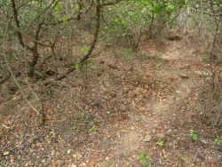
![]() Tuol Ta Meung (ទួលតាមឿង - Pronounced: Toohl Ta M'eung) a sizeable brick temple mound in the middle of the rice paddy fields, with a pile of excavated bricks and large schist slabs.
Tuol Ta Meung (ទួលតាមឿង - Pronounced: Toohl Ta M'eung) a sizeable brick temple mound in the middle of the rice paddy fields, with a pile of excavated bricks and large schist slabs.
Map Location
Image Gallery


If you would like to upload additional images to the gallery, please refer to the Upload Instructions guide
Historic Archive
A collection of historic photographs, artist sketches, maps etc. (Please ensure that anything you do upload is free of copyright and/or you have permission from the original photographer/artist/author to share)
Nearby Sites
- C0503087
- C0503088
- C0503090
- C0503100
- C0503103
- C0503104
- C0503105
- C0503106
- C0503160
- C0503161
- C0503162
- C0503163
- C0503164
- C0503165
- Tuol Prasat Cham (Kampong Speu)
- Tuol Prasat Eth
- Tuol Preah En
- Tuol Ta Meung
- Tuol Trapeang Chik Chhnang
- Wat Ang Phek
- Wat Ang Vien
- Wat Kiri Sophoar
- Wat Oudong Meanchey
- Wat Prei Kantoch
External Links
Links to additional resources such as articles, websites, videos etc.
References
Comments
Loading comments...