Kok Yeay Mau (Soutr Nikom)
| Native Name | គោកយាយម៉ៅ |
|---|---|
| BA# | C1711066 |
| CISARK# | 1247 |
| IK# | 573.06 |
| Size | Small |
| Condition | Tuol |
| Type | Temple |
| Location | |
| Village | Kbon or Thmei |
| Commune | Khchas |
| District | Soutr Nikom |
| Province | Siem Reap |
| Country | Cambodia |
| Coordinates | 13.28911, 104.07205 |
| History | |
| Material | Brick, Laterite, Sandstone |
| Year/s Restored | Destroyed |


![]()
![]() Kok Yeay Mau (គោកយាយម៉ៅ - Pronounced: Kouk Yi'aye Mauh!)
Kok Yeay Mau (គោកយាយម៉ៅ - Pronounced: Kouk Yi'aye Mauh!)
Early reports state that this site is the remains of a brick mound, with traces of sandstone blocks which would of formed the door frame, sandstone octagonal colonettes and fragments of laterite. The site is surrounded by a moat with an east entrance causeway and 100m to the east if a small rectangular man-made reservoir.
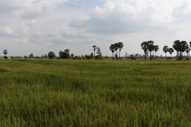
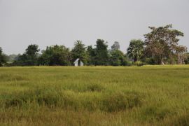
Upon a recent visit in 2022, we were unfortunately unable to see anything, as the whole area has now been ploughed and turned into rice paddy fields. There were no clear traces of any moats, causeways. Google satellite imagery in 2021 and early 2022 still showed the clear square moated temple site, though updated imagery at the end of 2022 now shows just a flat rice paddy field. Please see the first image in the gallery below to see the changes over the years to the site.
Map Location
Image Gallery
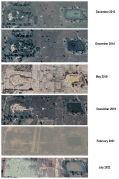
Satellite proof of the destruction


If you would like to upload additional images to the gallery, please refer to the Upload Instructions guide
Historic Archive
A collection of historic photographs, artist sketches, maps etc. (Please ensure that anything you do upload is free of copyright and/or you have permission from the original photographer/artist/author to share)
Nearby Sites
- Baray Kok Chambak La
- Baray Kok O Krah
- Baray Kok Yeay Tea
- Baray Prasat Ta Chey
- C1711222
- C1711223
- C1711224
- C1711225
- C1711230
- C1711268
- C1711269
- C1711270
- C1711271
- C1711311
- C1711312
- Kok Chambak La
- Kok Kroes (Daun Diev)
- Kok Kroes (Sanlong)
- Kok O Krah
- Kok Prasat Khnar Toch
- Kok Ta Khung
- Kok Yeay Mau (Prasat Bakong)
- Kok Yeay Tea
- Prasat Daun Deav
- Prasat Khla Krahoem
- Prasat Kok Prasat (Chan Sar)
- Prasat Sanlong
- Prasat Ta Chey (Soutr Nikom)
- Trapeang Khla Krahoem
External Links
Links to additional resources such as articles, websites, videos etc.
References